

El Nino Vs La Nina – what do they mean?
Sowing has officially kicked off in Australia with many starting off the season with good subsoil moisture after what most have hailed as decent autumn break. According to the Bureau of Meteorology (The Bureau), the long wet of the past three years has ended and Australia has entered into a neutral El Niño-Southern Oscillation (ENSO) phase. However, there is talk of the country plunging into El Niño in a few months, which could bring the opposite problem to what we’ve experienced over the past few years. So, what do these weather phases actually mean, how do they occur and why do they have such an impact on Australia’s winter crops?
Let’s start with the present.
Australia has just come out of a triple La Niña. That is, three years in a row where strong equatorial trade winds changed the ocean surface currents and drew cooler water up from below. This caused the central and eastern tropical Pacific Ocean to cool, in turn bringing above average rainfall and cooler temperatures to the east coast of Australia. This rain was beneficial for some. However, overall it saw large crops with low quality and in some cases, a complete washout of crops that were in the firing line of the constant wet.
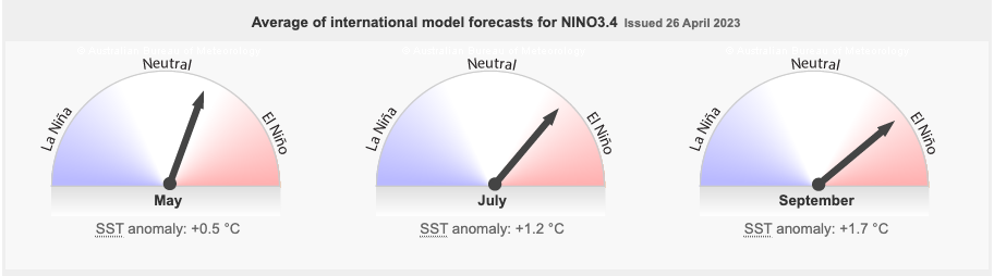
In early 2023, The Bureau officially announced that Australia had moved into a neutral ENSO phase, which is neither El Niño nor La Niña. When ENSO is neutral, the Pacific Ocean typically has little influence on Australian climate patterns. It’s expected this pattern will continue throughout autumn, but isn’t expected to stick around for much longer, with all but one climate model suggesting we’ll move into a El Nino phase by July, and all three models suggesting we’ll be in El Nino by August.
Australia on El Niño Watch.
When The Bureau announced the three year La Nina had ended, they also flagged the possibility of an El Nino forming later in the year and placed the country on El Nino Watch which means there is a 50% chance of El Nino forming during 2023.
El Nino occurs when sea surface temperatures in Pacific Ocean become warmer than average which causes tropical rainfall and cloud development. As a result, the heavy rainfall that usually occurs to the north of Australia moves to the central and eastern parts of the Pacific basin. This event typically brings warmer and dryer weather to the east coast of Australia, at a vital period in our winter crop development, spring.
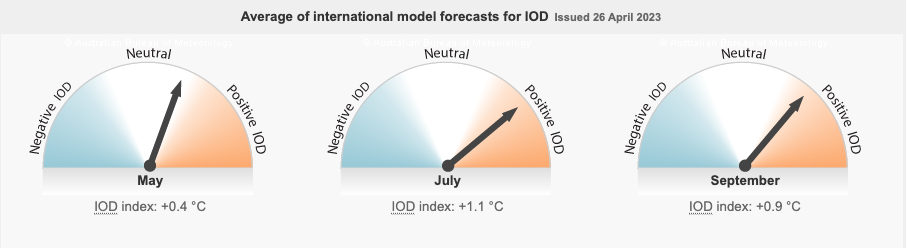
There are other climatic indicators that are closely monitored to determine the shift between La Nina and El Nino including the Indian Ocean Dipole (IOD), Southern Annular Mode (SAM) and Madden-Julian Oscillation (MJO).
IOD
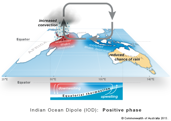
Many weather models are suggesting a positive IOD event may develop in the coming months. A positive IOD is often associated with El Nino and a negative IOD is typically associated with La Nina. The IOD is the difference in eastern and western Indian Ocean sea surface temperatures. Like ENSO, the change in temperature results in the rising and descending moisture and air. A positive IOD is known to reduce winter and spring rainfall over much of Australia.
MJO
The MJO is a climate driver used to monitor tropical weather around the globe. It is an eastward moving pulse of cloud and rainfall near the equator occurring every month to three months. It effects the timing, development and strength of the major global monsoon patterns, including Australian monsoons. It’s greatest effect on Australian rainfall occurs during the northern Australia wet season, which runs from October to April. Recent reports have shown that the MJO has strengthened and moved into the Western Pacific region. While in the Western Pacific, enhanced rainfall across parts of northern Australia and the Southwest Pacific is expected. This influence weakens as the MJO moves further east. For more information on the MJO, watch this short video. https://youtu.be/UsWHHE_jkGE
SAM
The contribution the SAM makes to Australia’s climate is a relatively new discovery. It refers to the north/south movement of westerly winds that dominate the middle to higher latitudes of the Southern Hemisphere. There are three phases to the SAM; neutral, positive and negative. During the summer and autumn months (December through to May) the SAM is showing an increasing tendency to remain in a positive phase which decreases the changes of rainfall from storm fronts across southern Australia.
So, what can we expect?
As mentioned, Australia is currently in ENSO Neutral. By monitoring the above mentioned climate drivers, The Bureau believes there is a 50% chance of an El Nino forming in 2023 with all three weather models indicating this will occur by August this year. The longer range forecasts also predict El Nino weather patterns to continue, however these are not known for their accuracy, so this information needs to be taken with a grain of salt and watched closely as we move through the winter months of 2023. Overall, Australia has had a relatively decent start to its cropping season, however, if El Nino predictions ring true, and the tap turns off over the winter months, we may see crop conditions start to deteriorate as we move through vital finish phase of the crop in September and October.
Source: information and images within this article has been sourced from the Australian Bureau of Meteorology BOM.GOV.AU.
The post <strong>El Nino Vs La Nina – what do they mean?</strong> appeared first on Basis Commodities.
Share This Article
Other articles you may like

Sign Up
Enter your email address below to sign up to the Basis Commodities newsletter.